

Who We Are
Bridging the Gap Between Reality and Digital Data.
Established in Delhi in 2020, Aaj Digital Services and Solutions brings over five years of hands-on field experience. We specialize in delivering accurate, reliable, and cost-effective survey solutions across diverse sectors including real estate, infrastructure, construction, power, and renewable energy.
Driven by a client-first approach, we focus on timely project execution and transparent communication. Our expertise spans topographical surveys, contour mapping, boundary demarcation, and sophisticated digital mapping.
- Latest Equipment (Total Station, DGPS, UAV)
- Government & Private Project Experience
- Transparent Communication & Integrity
Our Expertise
Comprehensive Surveying Solutions
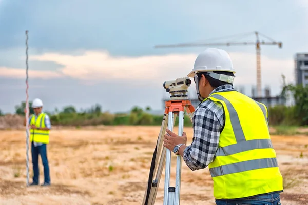
Advanced Land Surveying
Precision measurement using Total Stations, DGPS, and modern topographical methodologies.
Drone / UAV Mapping
High-resolution aerial data collection for large-scale infrastructure and agricultural projects.
GIS & Digital Mapping
Geographic Information System solutions for data visualization, analysis, and planning.
Why Choose Us
Distinguished by Quality & Expertise
At Aaj Digital Services and Solutions, we differentiate ourselves through a commitment to precision that goes beyond standard surveying. Our foundation is built on technical excellence and certified quality.
Unparalleled Expertise
Our team brings 31 years of experience and specialized training from M/s Topcon Sokkia Japan, offering elite knowledge in calibration and servicing.
Advanced Equipment
Our calibration labs are outfitted with the latest technology, including a four-tube collimator system, ensuring the highest levels of accuracy for your data.
Quality Assurance
We are an ISO 9001:2015 certified company using NABL/NPL calibrated masters to verify precision, earning the trust of clients across the industry.
Comprehensive Support
From sales to after-sales service, we provide end-to-end support to our clients, ensuring that equipment remains in peak condition throughout its lifecycle.
Adhering to strict quality standards with NABL/NPL calibrated masters for verifiable precision.

Founder's Message
"At Aaj Digital Services, our mission is simple: to provide data that you can build the future on. We blend traditional surveying integrity with modern technological precision to ensure every project stands on solid ground."
Testimonials
Trusted by Leaders in Infrastructure
"Aaj Digital Services provided exceptional accuracy for our route alignment project. Their use of DGPS technology saved us weeks of manual verification."

"The topographical maps delivered were incredibly detailed. Professional, timely, and easy to communicate with. Highly recommended."

"We utilized their drone mapping services for a solar park feasibility study. The data quality was top-notch and helped us optimize our layout significantly."
